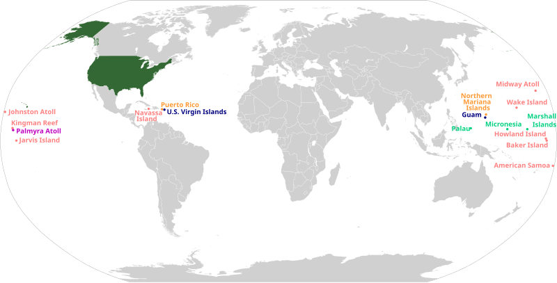
फाइल:US insular areas.svg

पूर्वावलोकन PNG क आकार SVG फाइल: ८०० × ४०६ चित्राणु दोसर resolutions: ३२० × १६२ चित्राणु | ६४० × ३२५ चित्राणु | १,०२४ × ५२० चित्राणु | १,२८० × ६५० चित्राणु | २,५६० × १,३०० चित्राणु | २,७५४ × १,३९८ चित्राणु।
पूर्ण आनन्तर्य (एसभिजी फाइल, मामूली रूपमे २,७५४ × १,३९८ चित्रकण, फाइलक आकार: १.०६ MB)
फाइल इतिहास
तखनका तिथि/ समए पर क्लिक करी जखनका फाइल देखबाक अछि
| तिथि/ समए | लघुचित्र | बीमसभ | प्रयोक्ता | समीक्षा | |
|---|---|---|---|---|---|
| अखनका | २०:३३, ६ अक्टुबर २०२३ |  | २,७५४ × १,३९८ (१.०६ MB) | LametinoWiki | File uploaded using svgtranslate tool (https://svgtranslate.toolforge.org/). Added translation for eu. |
| ००:२२, ३० मई २०२३ |  | २,७५४ × १,३९८ (१.०६ MB) | Aspere | File uploaded using svgtranslate tool (https://svgtranslate.toolforge.org/). Added translation for ko. | |
| ११:२७, २४ मई २०२३ |  | २,७५४ × १,३९८ (१.०६ MB) | Illchy | File uploaded using svgtranslate tool (https://svgtranslate.toolforge.org/). Added translation for id. | |
| १९:५९, ६ जुलाई २०२० |  | २,७५४ × १,३९८ (१.०६ MB) | Heitordp | Adjusted text alignment | |
| १९:३२, ६ जुलाई २०२० |  | २,७५४ × १,३९८ (१.०५ MB) | Heitordp | Corrected locations | |
| २३:४४, ५ मई २०२० |  | ५१२ × २६३ (१.५ MB) | Pharexia | improved readability of territories–added white background for visibility, minor color modification to align with USA locator map | |
| ०४:५९, २९ जनवरी २०२० |  | १,४७४ × ६२८ (६७९ KB) | JoKalliauer | Repaired file of 10:12, 5. Jan. 2020; phab:T217990, do not use SVGOMG on foreign files, see c:User:JoKalliauer/Optimization; please use Commons:Commons_SVG_Checker and File:Test.svg before uploading | |
| ०३:५८, ६ जनवरी २०२० |  | १,४७४ × ६२८ (१.९४ MB) | AndreyKva | Reverted to version as of 20:30, 5 January 2020 (UTC). Still appears to be broken. | |
| ०३:५५, ६ जनवरी २०२० |  | १,४७४ × ६२८ (८४६ KB) | AndreyKva | Second attempt at optimizing with SVGOMG. This time, precision is at a higher setting. I will revert if any issues arise (apologies for the failed upload last time). | |
| ०२:१५, ६ जनवरी २०२० |  | १,४७४ × ६२८ (१.९४ MB) | Ahmad252 | Reverted to version as of 09:13, 5 January 2020 (UTC): Still causes rendering problems on all pages the image has been used. |
फाइलक उपयोग
ई पृष्ठमे ई फाइलक लिङ्क अछि:
विश्वव्यापी फाइल उपयोग
ई फाइल कऽ उपयोग निम्न दोसर विकिसभमे अछि:
- af.wikipedia.org कऽ उपयोग पर
- ar.wikipedia.org कऽ उपयोग पर
- az.wikipedia.org कऽ उपयोग पर
- ban.wikipedia.org कऽ उपयोग पर
- ba.wikipedia.org कऽ उपयोग पर
- bg.wikipedia.org कऽ उपयोग पर
- bh.wikipedia.org कऽ उपयोग पर
- bjn.wikipedia.org कऽ उपयोग पर
- bn.wikipedia.org कऽ उपयोग पर
- bs.wikipedia.org कऽ उपयोग पर
- ca.wikipedia.org कऽ उपयोग पर
- cs.wikipedia.org कऽ उपयोग पर
- da.wikipedia.org कऽ उपयोग पर
- en.wikipedia.org कऽ उपयोग पर
- U.S. territorial sovereignty
- Lists of American universities and colleges
- 51st state
- Historical regions of the United States
- Insular area
- Territories of the United States
- User:Dangerous-Boy
- United States
- User:Buaidh
- Outline of the United States
- Talk:List of largest empires/Archive 2
- Talk:United States/Archive 37
- Talk:List of states and territories of the United States
- User:CaptainElena/sandbox
- User:Buaidh/sandbox
- User:SteveL1990/sandbox
- Template:Portal/doc/all
- User:Getaway Car/vinceroyalty
- User:NiklawskiMSTM/Iodni zad
- User:Garaziarana/Sandbox/Infobox/Country
- User:Callejandrea/Sandbox/Infobox/Country
- User:Estibalizdelgado/sandbox/Infobox/Country
- User:Laura G.Cabriada/sandbox/Infobox/Place
- User:Paul.deprado/Infobox/Country
- User:Paul.deprado/sandbox/Infobox/Country
- User:Paulabente/sandbox/Infobox/Country
- User:Arrate.catarain/Sandbox/Infoboxes/Place
- User:Gorkagomez87/sandbox/Infobox/Country
- Wikipedia:WikiProject United States Territories
- Talk:United States/Archive 81
- User:Stephen100002/sandbox
- User:TheSaint250/sandbox
ई फाइलक विश्वव्यापी उपयोगक अधिक जानकारी देखी।