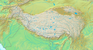
फाइल:Topografic map of Tibetan Plateau.png

ऐ पूर्वदृश्यक आकार: ८०० × ४२९ चित्राणु. दोसर resolutions: ३२० × १७२ चित्राणु | ६४० × ३४३ चित्राणु | १,३६५ × ७३२ चित्राणु।
पूर्ण आनन्तर्य (१,३६५ × ७३२ चित्राणु, फाइल आकार: ६६३ KB, माइम प्रकार: image/png)
| ई फाइल विकिमिडिया कमन्ससँ अछि। कमन्सकs विवरण पृष्ठसँ जानकारी एतए नीचाँ देखाएल गेल अछि। कमन्स एक फ्रि लाइसेन्स मिडिया फाइल परियोजना छि। अपने मद्ददतकs सकए छि। |
| जानकारी |
English: Topografic map of the Tibetan Plateau in Asia.
Français : Carte topographique du plateau tibetain.
|
||||
| दिनाङ्क | अज्ञात तारीख | ||||
| स्रोत | http://www.demis.nl/home/pages/Gallery/examples.htm | ||||
| लेखक | अनजान | ||||
| अनुमति (ई फाइलक पुनः उपयोग) |
|
फाइल इतिहास
तखनका तिथि/ समए पर क्लिक करी जखनका फाइल देखबाक अछि
| तिथि/ समए | लघुचित्र | बीमसभ | प्रयोक्ता | समीक्षा | |
|---|---|---|---|---|---|
| अखनका | ०१:३६, २७ मार्च २००९ | | १,३६५ × ७३२ (६६३ KB) | Botev | borders bold, lakes filled in blue |
| ००:४७, ३ सितम्बर २००५ |  | १,३६५ × ७३२ (७१० KB) | Mats Halldin~commonswiki | Map of Himalaya Bounding box West 66°, South 23°, East 108°, North 42°. {{demis-pd}} category:maps of Himalaya |
फाइलक उपयोग
ई 3 पन्नासभमे ई फाइलक लिङ्क अछि:
विश्वव्यापी फाइल उपयोग
ई फाइल कऽ उपयोग निम्न दोसर विकिसभमे अछि:
- ar.wikipedia.org कऽ उपयोग पर
- ba.wikipedia.org कऽ उपयोग पर
- be-tarask.wikipedia.org कऽ उपयोग पर
- bn.wikipedia.org कऽ उपयोग पर
- ceb.wikipedia.org कऽ उपयोग पर
- ce.wikipedia.org कऽ उपयोग पर
- da.wikipedia.org कऽ उपयोग पर
- de.wikipedia.org कऽ उपयोग पर
- en.wikipedia.org कऽ उपयोग पर
- Gyachung Kang
- 1950 Assam–Tibet earthquake
- Geladaindong Peak
- Karuo culture
- Haba Snow Mountain
- Anisodus tanguticus
- Outline of Tibet
- Alpine steppe
- Kang Yatze
- Module:Location map/data/Tibetan Plateau/doc
- User:BIO341prj
- 1927 Gulang earthquake
- 1932 Changma earthquake
- Pauhunri
- Guozha Lake
- User:HueSatLum/II
- Singhi Kangri
- Module:Location map/data/Tibetan Plateau
- Gasherbrum VI
- Phrynocephalus vlangalii
- eu.wikipedia.org कऽ उपयोग पर
- fa.wikipedia.org कऽ उपयोग पर
- fo.wikipedia.org कऽ उपयोग पर
- fr.wikipedia.org कऽ उपयोग पर
- fr.wikibooks.org कऽ उपयोग पर
- gcr.wikipedia.org कऽ उपयोग पर
- hi.wikipedia.org कऽ उपयोग पर
ई फाइलक विश्वव्यापी उपयोगक अधिक जानकारी देखी।