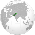
फाइल:Pakistan (orthographic projection).svg

पूर्वावलोकन PNG क आकार SVG फाइल: ५४१ × ५४१ चित्राणु दोसर resolutions: २४० × २४० चित्राणु | ४८० × ४८० चित्राणु | ७६८ × ७६८ चित्राणु | १,०२४ × १,०२४ चित्राणु | २,०४८ × २,०४८ चित्राणु।
पूर्ण आनन्तर्य (एसभिजी फाइल, मामूली रूपमे ५४१ × ५४१ चित्रकण, फाइलक आकार: २६८ KB)
फाइल इतिहास
तखनका तिथि/ समए पर क्लिक करी जखनका फाइल देखबाक अछि
| तिथि/ समए | लघुचित्र | बीमसभ | प्रयोक्ता | समीक्षा | |
|---|---|---|---|---|---|
| अखनका | १२:१७, १७ नवम्बर २०२१ |  | ५४१ × ५४१ (२६८ KB) | Gotitbro | Reverted to version as of 19:17, 10 November 2021 (UTC) gain consensus on enwiki or here, rather than edit warring; FWIW the discussion was on the svg editor's talk |
| १४:०७, १२ नवम्बर २०२१ |  | ५४१ × ५४१ (२८० KB) | Ytpks896 | Reverted to version as of 06:39, 24 October 2021 (UTC) All sources are provided for this, your self made discussion on your talk page doesn't matter, if you want to dispute it the start discussion on File talk page not yours | |
| ०१:०२, ११ नवम्बर २०२१ |  | ५४१ × ५४१ (२६८ KB) | Gotitbro | Reverted to version as of 05:04, 11 October 2021 (UTC) there is a linked discussion in the ES, no consensus at either enwiki or commons | |
| १२:२४, २४ अक्टुबर २०२१ |  | ५४१ × ५४१ (२८० KB) | Ytpks896 | Reverted to version as of 10:39, 16 September 2021 (UTC) rvt this territory is disputed & claimed by the Pakistan, and also territory was included in official map of Pakistan all sources was provided about this, removing territory from map and providing summary not a 'new' claim; without any source or reference this is not a logic. | |
| १०:४९, ११ अक्टुबर २०२१ |  | ५४१ × ५४१ (२६८ KB) | Gotitbro | Reverted to version as of 16:08, 13 May 2020 (UTC) rvt contentious, not a 'new' claim; see User talk:Goran tek-en | |
| १६:२४, १६ सितम्बर २०२१ |  | ५४१ × ५४१ (२८० KB) | Veverve | Reverted to version as of 12:10, 14 August 2021 (UTC) see summary for the source | |
| १३:५५, १६ सितम्बर २०२१ |  | ५४१ × ५४१ (१६८ KB) | Ksh.andronexus | Reverted to version as of 08:08, 16 September 2021 (UTC) | |
| १३:५४, १६ सितम्बर २०२१ |  | ५४१ × ५४१ (२६८ KB) | Ksh.andronexus | Reverted to version as of 08:06, 16 September 2021 (UTC) | |
| १३:५३, १६ सितम्बर २०२१ |  | ५४१ × ५४१ (१६८ KB) | Ksh.andronexus | Reverted to version as of 02:40, 9 January 2017 (UTC) | |
| १३:५१, १६ सितम्बर २०२१ |  | ५४१ × ५४१ (२६८ KB) | Ksh.andronexus | Is Pakistan on drugs to claim junagarh, please add a reference that is considerable, vandalising wiki leads to ban |
फाइलक उपयोग
ई पृष्ठमे ई फाइलक लिङ्क अछि:
विश्वव्यापी फाइल उपयोग
ई फाइल कऽ उपयोग निम्न दोसर विकिसभमे अछि:
- ace.wikipedia.org कऽ उपयोग पर
- ady.wikipedia.org कऽ उपयोग पर
- af.wikipedia.org कऽ उपयोग पर
- ami.wikipedia.org कऽ उपयोग पर
- ar.wikipedia.org कऽ उपयोग पर
- ar.wiktionary.org कऽ उपयोग पर
- as.wikipedia.org कऽ उपयोग पर
- av.wikipedia.org कऽ उपयोग पर
- awa.wikipedia.org कऽ उपयोग पर
- azb.wikipedia.org कऽ उपयोग पर
- az.wiktionary.org कऽ उपयोग पर
- ba.wikipedia.org कऽ उपयोग पर
- bcl.wikipedia.org कऽ उपयोग पर
- bh.wikipedia.org कऽ उपयोग पर
- bn.wikipedia.org कऽ उपयोग पर
- bo.wikipedia.org कऽ उपयोग पर
- bpy.wikipedia.org कऽ उपयोग पर
- bxr.wikipedia.org कऽ उपयोग पर
- cdo.wikipedia.org कऽ उपयोग पर
- ceb.wikipedia.org कऽ उपयोग पर
- chr.wikipedia.org कऽ उपयोग पर
- ch.wikipedia.org कऽ उपयोग पर
- crh.wikipedia.org कऽ उपयोग पर
- cs.wikipedia.org कऽ उपयोग पर
- cu.wikipedia.org कऽ उपयोग पर
- cv.wikipedia.org कऽ उपयोग पर
- da.wikipedia.org कऽ उपयोग पर
- dty.wikipedia.org कऽ उपयोग पर
- el.wikipedia.org कऽ उपयोग पर
- en.wikipedia.org कऽ उपयोग पर
ई फाइलक विश्वव्यापी उपयोगक अधिक जानकारी देखी।


