फाइल:Ladakh locator map.svg

पूर्वावलोकन PNG क आकार SVG फाइल: ७६४ × ६०० चित्राणु दोसर resolutions: ३०६ × २४० चित्राणु | ६११ × ४८० चित्राणु | ९७८ × ७६८ चित्राणु | १,२८० × १,००५ चित्राणु | २,५६० × २,०१० चित्राणु | २,१६० × १,६९६ चित्राणु।
पूर्ण आनन्तर्य (एसभिजी फाइल, मामूली रूपमे २,१६० × १,६९६ चित्रकण, फाइलक आकार: २०२ KB)
| ई फाइल विकिमिडिया कमन्ससँ अछि। कमन्सकs विवरण पृष्ठसँ जानकारी एतए नीचाँ देखाएल गेल अछि। कमन्स एक फ्रि लाइसेन्स मिडिया फाइल परियोजना छि। अपने मद्ददतकs सकए छि। |
| शीर्षक |
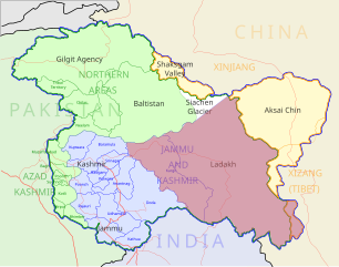
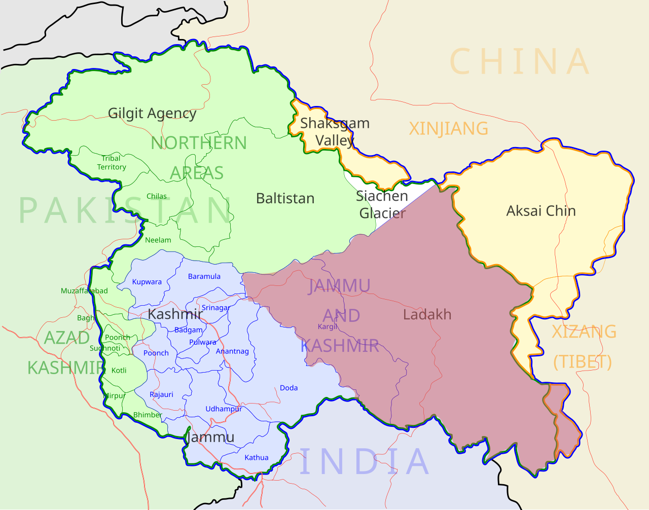
Ladakh locator map |
| Description |
Locator map for the region of w:Ladakh (higlighted in red) in the w:Indian state of w:Jammu and Kashmir |
| दिनाङ्क | |
| स्रोत |
अपन काम |
| रचियता | |
| अनुमति (ई फाइलक पुनः उपयोग) |
मैं, इस कार्य का/की कॉपीराइट धारक, इसे निम्न लाइसेंस के अंतर्गत प्रकाशित करता/करती हूँ: ई फाइल लाइसेन्सड अछि एहि अन्तर्गत क्रिएटिभ कमन्स एट्रिब्युसन-सेयर अलाइक ३.० अनपोर्टेड लाईसेन्स ।
|
| Geotemporal data | |
| Date depicted | second half of 20 century आर 21 century |
| Georeferencing | If inappropriate please set warp_status = skip to hide. |
| Archival data | |
| नोट्स | Part of WikiProject India Maps |
फाइल इतिहास
तखनका तिथि/ समए पर क्लिक करी जखनका फाइल देखबाक अछि
| तिथि/ समए | लघुचित्र | बीमसभ | प्रयोक्ता | समीक्षा | |
|---|---|---|---|---|---|
| अखनका | ११:३५, २ दिसम्बर २०१२ | | २,१६० × १,६९६ (२०२ KB) | Baomi | 改“XIJANG”为“XIZANG” |
| ०६:०९, १० मई २००७ |  | २,१६० × १,६९६ (२६० KB) | Saravask | {{WikiProject_India_Maps |Title=Ladakh locator map |Description=Locator map for the region of w:Ladakh (higlighted in red) in the w:Indian state of [w:Jammu and Kashmir]] |Source= [http://www.koausa.org/Nature/maps.html Map of Kashmir], |Date=May |
फाइलक उपयोग
ई 2 पन्नासभमे ई फाइलक लिङ्क अछि:
विश्वव्यापी फाइल उपयोग
ई फाइल कऽ उपयोग निम्न दोसर विकिसभमे अछि:
- as.wikipedia.org कऽ उपयोग पर
- awa.wikipedia.org कऽ उपयोग पर
- bpy.wikipedia.org कऽ उपयोग पर
- ceb.wikipedia.org कऽ उपयोग पर
- en.wikipedia.org कऽ उपयोग पर
- fa.wikipedia.org कऽ उपयोग पर
- he.wikipedia.org कऽ उपयोग पर
- hi.wikipedia.org कऽ उपयोग पर
- hu.wikipedia.org कऽ उपयोग पर
- incubator.wikimedia.org कऽ उपयोग पर
- it.wikipedia.org कऽ उपयोग पर
- it.wikivoyage.org कऽ उपयोग पर
- ja.wikipedia.org कऽ उपयोग पर
- ko.wikipedia.org कऽ उपयोग पर
- ml.wikipedia.org कऽ उपयोग पर
- nn.wikipedia.org कऽ उपयोग पर
- no.wikipedia.org कऽ उपयोग पर
- or.wikipedia.org कऽ उपयोग पर
- pam.wikipedia.org कऽ उपयोग पर
- pnb.wikipedia.org कऽ उपयोग पर
ई फाइलक विश्वव्यापी उपयोगक अधिक जानकारी देखी।