फाइल:LA County Incorporated Areas Los Angeles highlighted.svg

पूर्वावलोकन PNG क आकार SVG फाइल: ७३० × ५९९ चित्राणु दोसर resolutions: २९२ × २४० चित्राणु | ५८५ × ४८० चित्राणु | ९३५ × ७६८ चित्राणु | १,२४७ × १,०२४ चित्राणु | २,४९४ × २,०४८ चित्राणु | ९५० × ७८० चित्राणु।
पूर्ण आनन्तर्य (एसभिजी फाइल, मामूली रूपमे ९५० × ७८० चित्रकण, फाइलक आकार: २६१ KB)
| ई फाइल विकिमिडिया कमन्ससँ अछि। कमन्सकs विवरण पृष्ठसँ जानकारी एतए नीचाँ देखाएल गेल अछि। कमन्स एक फ्रि लाइसेन्स मिडिया फाइल परियोजना छि। अपने मद्ददतकs सकए छि। |
सङ्क्षेप
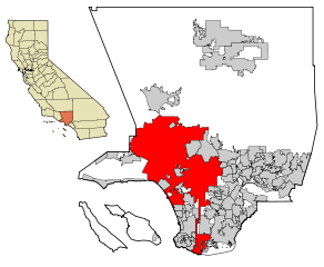
| जानकारी | This map shows the incorporated areas in Los Angeles County, California. Los Angeles is highlighted in red. I created it in Inkscape using data from the Los Angeles County Website (Los Angeles County Incorporated Area and District Map (PDF). |
| दिनाङ्क | |
| स्रोत | My own work, based on public domain information. Though I strove to be as accurate in the detail as possible, the information shown is not guaranteed to be completely accurate. |
| लेखक | Ixnayonthetimmay |
| अनुमति (ई फाइलक पुनः उपयोग) |
Public Domain |
| दूसरे संस्करण | See Category:Maps of Los Angeles County, California for other versions of this image. |
अधिकृत करब
| मैं, इस कार्य का/की कॉपीराइट धारक, इस कार्य को सार्वजनिक डोमेन में प्रकाशित करता/करती हूँ। यह पूरे विश्व में लागू होता है। कुछ देशों में यह कानूनी तौर पर नहीं हो सकता है; ऐसा हो तो: मैं सभी को इस कार्य का इस्तेमाल किसी भी उद्देश्य से, बिना किसी बाधाओं के इन शर्तों के कानून द्वारा अनिवार्य किए तक करने की अनुमति देता/देती हूँ। |
फाइल इतिहास
तखनका तिथि/ समए पर क्लिक करी जखनका फाइल देखबाक अछि
| तिथि/ समए | लघुचित्र | बीमसभ | प्रयोक्ता | समीक्षा | |
|---|---|---|---|---|---|
| अखनका | १३:०४, २६ जुन २००७ | | ९५० × ७८० (२६१ KB) | Ixnayonthetimmay | == Summary == {{Information |Description=This map shows the incorporated areas in Los Angeles County, California. Los Angeles is highlighted in |
फाइलक उपयोग
ई पृष्ठमे ई फाइलक लिङ्क अछि:
विश्वव्यापी फाइल उपयोग
ई फाइल कऽ उपयोग निम्न दोसर विकिसभमे अछि:
- af.wikipedia.org कऽ उपयोग पर
- als.wikipedia.org कऽ उपयोग पर
- ang.wikipedia.org कऽ उपयोग पर
- ar.wikipedia.org कऽ उपयोग पर
- arz.wikipedia.org कऽ उपयोग पर
- ast.wikipedia.org कऽ उपयोग पर
- azb.wikipedia.org कऽ उपयोग पर
- bg.wikipedia.org कऽ उपयोग पर
- bh.wikipedia.org कऽ उपयोग पर
- bn.wikipedia.org कऽ उपयोग पर
- ca.wikipedia.org कऽ उपयोग पर
- chy.wikipedia.org कऽ उपयोग पर
- de.wikipedia.org कऽ उपयोग पर
- diq.wikipedia.org कऽ उपयोग पर
- dty.wikipedia.org कऽ उपयोग पर
- el.wikipedia.org कऽ उपयोग पर
- en.wikipedia.org कऽ उपयोग पर
- Los Angeles
- Los Angeles Police Department
- Harbor Gateway, Los Angeles
- Municipal annexation in the United States
- Category:Neighborhoods in Los Angeles
- National Register of Historic Places listings in Los Angeles
- Killing of Ezell Ford
- Wikipedia talk:WikiProject China/Archive 26
- Talk:New York (state)/Archive 7
- User:Hparham865
- User:Nate.beisheim/sandbox10
- en.wikinews.org कऽ उपयोग पर
- es.wikipedia.org कऽ उपयोग पर
- eu.wikipedia.org कऽ उपयोग पर
- ext.wikipedia.org कऽ उपयोग पर
- fa.wikipedia.org कऽ उपयोग पर
- fi.wikipedia.org कऽ उपयोग पर
- fo.wikipedia.org कऽ उपयोग पर
- fr.wikipedia.org कऽ उपयोग पर
- Los Angeles
- Projet:Charte graphique/Domaine géographique
- Los Angeles Police Department
- Modèle:Infobox Ville des États-Unis
- Modèle:Infobox Ville des États-Unis/Documentation
- Gangster Squad (LAPD)
- Community Resources Against Street Hoodlums
- Division métropolitaine du Los Angeles Police Department
- Modèle:Infobox Ville des États-Unis/Bac à sable
- fr.wikinews.org कऽ उपयोग पर
- fy.wikipedia.org कऽ उपयोग पर
ई फाइलक विश्वव्यापी उपयोगक अधिक जानकारी देखी।