फाइल:Kagbeni Mustang-WLV-0741.jpg

ऐ पूर्वदृश्यक आकार: ८०० × ५३३ चित्राणु. दोसर resolutions: ३२० × २१३ चित्राणु | ६४० × ४२७ चित्राणु | १,०२४ × ६८३ चित्राणु | १,२८० × ८५३ चित्राणु | २,५६० × १,७०६ चित्राणु | ५,०२७ × ३,३५१ चित्राणु।
पूर्ण आनन्तर्य (५,०२७ × ३,३५१ चित्राणु, फाइल आकार: ११.१२ MB, माइम प्रकार: image/jpeg)
| ई फाइल विकिमिडिया कमन्ससँ अछि। कमन्सकs विवरण पृष्ठसँ जानकारी एतए नीचाँ देखाएल गेल अछि। कमन्स एक फ्रि लाइसेन्स मिडिया फाइल परियोजना छि। अपने मद्ददतकs सकए छि। |
सङ्क्षेप
| जानकारी |
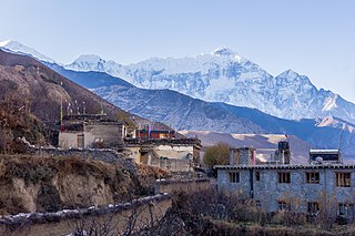
English: Kagbeni is a village in the Upper Mustang of the Himalayas, in Nepal, located in the valley of the Kali Gandaki River. Administratively, Kagbeni is a Village Development Committee in Mustang District in the Dhawalagiri Zone of northern Nepal. At the time of the 1991 Nepal census it had a population of 1200 people residing in 260 individual households. [1] It lies on the trail from Jomsom to the royal capital Lo Manthang, near the junction with the trail to Muktinath. |
|||||||||||||||||||||||
| दिनाङ्क | ||||||||||||||||||||||||
| स्रोत | अपन काम | |||||||||||||||||||||||
| लेखक |
|
|||||||||||||||||||||||

| कैमरा स्थान | | यह और अन्य आसपास की छवियों यहां पर देखें: ओपन स्ट्रीट मैप |
|---|
Assessment
|
अधिकृत करब
|

इस फ़ाइल को क्रिएटिव कॉमन्स श्रेय-समानसांझा 4.0 अंतर्राष्ट्रीय लाइसेंस के अंतर्गत लाइसेंस किया गया है।
एट्रिब्युसन: Bijay chaurasia
- अहाँ मुक्त छी:
- साझा करी – रचनाक कपी, वितरित आ सञ्चारित करवाक लेल
- रिमिक्स करैक लेल – काम अनुकूलित करैक लेल
- निम्नलिखित कारणसभक अन्तर्गत:
- एट्रीब्यूसन – अहाँक रचनाक श्रेय लाइसेन्सकर्ता अथवा लेखकके बताएल गएल माध्यमसँ देबए पडत (मुदा ई प्रकार नै की वोसँ लागै कि ओ अहाँक अथवा अहाँकद्वारा रचनाक प्रयोग क समर्थन करैत अछि)।
- शेयर एलाइक – यदि अहाँ ई रचनामे कोनो परिवर्तन अथवा बदलाव करैत छी या एहिपर आधारित किछो रचित करैत छी तँ अहाँ निष्कर्ष स्वरूप बनल रचनाक मात्र एहि या एकर सामान कोनो same or compatible लाइसेन्सक अन्तर्गत वितरित करि सकैत छी।

|
This image was uploaded as part of Wiki Loves Villages.
|
फाइल इतिहास
तखनका तिथि/ समए पर क्लिक करी जखनका फाइल देखबाक अछि
| तिथि/ समए | लघुचित्र | बीमसभ | प्रयोक्ता | समीक्षा | |
|---|---|---|---|---|---|
| अखनका | १५:५८, ३ जुन २०१८ | | ५,०२७ × ३,३५१ (११.१२ MB) | Bijay Chaurasia | reupload |
| १९:४९, २७ जनवरी २०१८ |  | ५,०२७ × ३,३५१ (१.९१ MB) | Bijay Chaurasia | User created page with UploadWizard |
फाइलक उपयोग
ई 2 पन्नासभमे ई फाइलक लिङ्क अछि:
विश्वव्यापी फाइल उपयोग
ई फाइल कऽ उपयोग निम्न दोसर विकिसभमे अछि:
- de.wikipedia.org कऽ उपयोग पर
- en.wikipedia.org कऽ उपयोग पर
- fr.wikipedia.org कऽ उपयोग पर
- ha.wikipedia.org कऽ उपयोग पर
- hi.wikipedia.org कऽ उपयोग पर
- ne.wikipedia.org कऽ उपयोग पर
- pt.wikipedia.org कऽ उपयोग पर
- ta.wikipedia.org कऽ उपयोग पर