फाइल:Great Lakes from space crop labeled.jpg
ऐसँ बेशी आनन्तर्य उपलब्ध नै अछि।
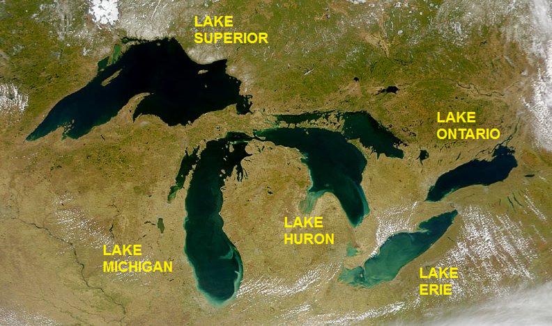
Great_Lakes_from_space_crop_labeled.jpg (७९२ × ४६९ चित्राणु, फाइल आकार: ९६ KB, माइम प्रकार: image/jpeg)
| ई फाइल विकिमिडिया कमन्ससँ अछि। कमन्सकs विवरण पृष्ठसँ जानकारी एतए नीचाँ देखाएल गेल अछि। कमन्स एक फ्रि लाइसेन्स मिडिया फाइल परियोजना छि। अपने मद्ददतकs सकए छि। |
सङ्क्षेप
| जानकारी | Satellite image of the Great Lakes from space |
| दिनाङ्क | |
| स्रोत | http://visibleearth.nasa.gov/view_rec.php?id=793 |
| लेखक | SeaWiFS Project, NASA/Goddard Space Flight Center, and ORBIMAGE; cropped and labeled by Beyond My Ken (talk) 05:49, 11 September 2012 (UTC) |
| दूसरे संस्करण |
  |
अधिकृत करब
| This image is from the Sea-viewing Wide Field-of-view Sensor (SeaWiFS) Project and more than 5 years old.
Satellite data captured by the SeaWIFS sensor are released into the public domain 5 years after capture. Data less than five years old can be re-used only for educational or scientific purposes; any commercial use of such images must be coordinated with GeoEye. [1] |
| This work has been released into the public domain by its copyright holder, GeoEye. This applies worldwide. कुछ देशों में यह कानूनी तौर पर नहीं हो सकता है; ऐसा हो तो: GeoEye सभी को इस कार्य का इस्तेमाल किसी भी उद्देश्य से, बिना किसी बाधाओं के इन शर्तों के कानून द्वारा अनिवार्य किए तक करने की अनुमति देता/देती हैं।
|
फाइल इतिहास
तखनका तिथि/ समए पर क्लिक करी जखनका फाइल देखबाक अछि
| तिथि/ समए | लघुचित्र | बीमसभ | प्रयोक्ता | समीक्षा | |
|---|---|---|---|---|---|
| अखनका | ११:३४, ११ सितम्बर २०१२ | | ७९२ × ४६९ (९६ KB) | Beyond My Ken | == {{int:filedesc}} == {{Information |Description= Satellite image of the Great Lakes from space |Source= http://visibleearth.nasa.gov/view_rec.php?id=793 |Date= 2000-04-24 |Author= SeaWiFS Project, NASA/Goddard Space Flight Center, and ORBIMAGE; cropp... |
फाइलक उपयोग
ई पृष्ठमे ई फाइलक लिङ्क अछि:
विश्वव्यापी फाइल उपयोग
ई फाइल कऽ उपयोग निम्न दोसर विकिसभमे अछि:
- am.wikipedia.org कऽ उपयोग पर
- as.wikipedia.org कऽ उपयोग पर
- be.wikipedia.org कऽ उपयोग पर
- bh.wikipedia.org कऽ उपयोग पर
- bn.wikipedia.org कऽ उपयोग पर
- bs.wikipedia.org कऽ उपयोग पर
- bxr.wikipedia.org कऽ उपयोग पर
- ce.wikipedia.org कऽ उपयोग पर
- ckb.wikipedia.org कऽ उपयोग पर
- en.wikipedia.org कऽ उपयोग पर
- en.wikibooks.org कऽ उपयोग पर
- eo.wikipedia.org कऽ उपयोग पर
- eu.wikipedia.org कऽ उपयोग पर
- gl.wikipedia.org कऽ उपयोग पर
- he.wikipedia.org कऽ उपयोग पर
- he.wikivoyage.org कऽ उपयोग पर
- hy.wikipedia.org कऽ उपयोग पर
- ilo.wikipedia.org कऽ उपयोग पर
- lfn.wikipedia.org कऽ उपयोग पर
- ne.wikipedia.org कऽ उपयोग पर
- new.wikipedia.org कऽ उपयोग पर
- pa.wikipedia.org कऽ उपयोग पर
- pt.wikipedia.org कऽ उपयोग पर
- udm.wikipedia.org कऽ उपयोग पर
- uz.wikipedia.org कऽ उपयोग पर