फाइल:ElectoralCollege2004.svg

पूर्ण आनन्तर्य (एसभिजी फाइल, मामूली रूपमे १,०२० × ५९३ चित्रकण, फाइलक आकार: २९ KB)
| ई फाइल विकिमिडिया कमन्ससँ अछि। कमन्सकs विवरण पृष्ठसँ जानकारी एतए नीचाँ देखाएल गेल अछि। कमन्स एक फ्रि लाइसेन्स मिडिया फाइल परियोजना छि। अपने मद्ददतकs सकए छि। |
सङ्क्षेप
| U.S. presidential election maps (SVG) |
| See also: National Atlas maps (png) |
|
1789 · 1792 · 1796 · 1800 · 1804 · 1808 · 1812 · 1816 · 1820 · 1824 · 1828 · 1832 · 1836 · 1840 · 1844 · 1848 · 1852 · 1856 · 1860 · 1864 · 1868 · 1872 · 1876 · 1880 · 1884 · 1888 · 1892 · 1896 · 1900 · 1904 · 1908 · 1912 · 1916 · 1920 · 1924 · 1928 · 1932 · 1936 · 1940 · 1944 · 1948 · 1952 · 1956 · 1960 · 1964 · 1968 · 1972 · 1976 · 1980 · 1984 · 1988 · 1992 · 1996 · 2000 · 2004 · 2008 · 2012 · 2016 · 2020 · 2024 |
| जानकारी |
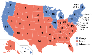
English: Electoral college votes in the 2004 United States Presidential election |
| दिनाङ्क | |
| स्रोत | अपन काम |
| लेखक | Nkocharh (talk) |
अधिकृत करब
| इस कार्य को इसके लेखक, अंगरेजी विकिपिडिया पर Nkocharh द्वारा सार्वजनिक डोमेन में प्रकाशित किया गया है। यह पूरे विश्व में लागू होता है। कुछ देशों में यह कानूनी तौर पर नहीं हो सकता है; ऐसा हो तो: Nkocharh सभी को इस कार्य का इस्तेमाल किसी भी उद्देश्य से, बिना किसी बाधाओं के इन शर्तों के कानून द्वारा अनिवार्य किए तक करने की अनुमति देता/देती हैं। |
मूल अपलोड लॉग
Transferred from en.wikipedia to Commons by Furfur using CommonsHelper.
- 2008-03-06 21:49 Nkocharh 1020×593×??? (122642 bytes) Desaturated the colors to match all the other maps to be found here: http://en.wikipedia.org/wiki/United_States_presidential_election_maps
फाइल इतिहास
तखनका तिथि/ समए पर क्लिक करी जखनका फाइल देखबाक अछि
| तिथि/ समए | लघुचित्र | बीमसभ | प्रयोक्ता | समीक्षा | |
|---|---|---|---|---|---|
| अखनका | १४:१०, २२ दिसम्बर २०१८ | | १,०२० × ५९३ (२९ KB) | Newfraferz87 | New template |
| १६:४४, ६ फरबरी २०१७ |  | १,०२० × ५९३ (३५ KB) | Newfraferz87 | Clearer state borders | |
| ०९:३७, २१ दिसम्बर २०१६ |  | १,०२० × ५९३ (३५ KB) | Newfraferz87 | There's no need to make that distinction; there was only one "Bush" running for president that year. | |
| १८:५३, ११ दिसम्बर २०१६ |  | १,०२० × ५९३ (११४ KB) | Χ | label G.W. Bush | |
| ०३:४५, ८ नवम्बर २०१६ |  | १,०२० × ५९३ (१२० KB) | Wow | Edwards | |
| ०२:५१, ३ सितम्बर २००८ |  | १,०२० × ५९३ (१२० KB) | File Upload Bot (Magnus Manske) | {{BotMoveToCommons|en.wikipedia}} {{Information |Description={{en|Electoral college votes in the 2004 United States Presidential election<br/> en:Category:Maps of the United States en:Category:United States presidential election, 2004 [[:en:Ca |
फाइलक उपयोग
ई 2 पन्नासभमे ई फाइलक लिङ्क अछि:
विश्वव्यापी फाइल उपयोग
ई फाइल कऽ उपयोग निम्न दोसर विकिसभमे अछि:
- arz.wikipedia.org कऽ उपयोग पर
- as.wikipedia.org कऽ उपयोग पर
- azb.wikipedia.org कऽ उपयोग पर
- bg.wikipedia.org कऽ उपयोग पर
- bh.wikipedia.org कऽ उपयोग पर
- bs.wikipedia.org कऽ उपयोग पर
- cdo.wikipedia.org कऽ उपयोग पर
- cy.wikipedia.org कऽ उपयोग पर
- dag.wikipedia.org कऽ उपयोग पर
- da.wikipedia.org कऽ उपयोग पर
- de.wikipedia.org कऽ उपयोग पर
- el.wikipedia.org कऽ उपयोग पर
- eml.wikipedia.org कऽ उपयोग पर
- en.wikipedia.org कऽ उपयोग पर
- Presidency of George W. Bush
- 2004 United States presidential election
- 2004 United States presidential election in California
- 2004 United States presidential election in Illinois
- 2004 United States presidential election in Texas
- 2004 United States presidential election in Florida
- 2004 United States presidential election in Pennsylvania
- 2004 United States presidential election in Ohio
- 2004 United States presidential election in Georgia
- 2004 United States presidential election in Iowa
- 2004 United States presidential election in New Jersey
- 2004 United States presidential election in Wisconsin
- 2004 United States presidential election in Alabama
- 2004 United States presidential election in Arizona
- 2004 United States presidential election in Arkansas
- 2004 United States presidential election in Colorado
- 2004 United States presidential election in Delaware
- 2004 United States presidential election in Connecticut
- 2004 United States presidential election in Hawaii
- 2004 United States presidential election in New York
- 2004 United States presidential election in New Hampshire
- 2004 United States presidential election in Vermont
ई फाइलक विश्वव्यापी उपयोगक अधिक जानकारी देखी।