फाइल:Canton1860.jpg

ऐ पूर्वदृश्यक आकार: ८०० × ४५७ चित्राणु. दोसर resolutions: ३२० × १८३ चित्राणु | ६४० × ३६६ चित्राणु | १,०२४ × ५८५ चित्राणु | १,२८० × ७३१ चित्राणु | २,५६० × १,४६२ चित्राणु | ११,६८० × ६,६७२ चित्राणु।
पूर्ण आनन्तर्य (११,६८० × ६,६७२ चित्राणु, फाइल आकार: ११.७२ MB, माइम प्रकार: image/jpeg)
| ई फाइल विकिमिडिया कमन्ससँ अछि। कमन्सकs विवरण पृष्ठसँ जानकारी एतए नीचाँ देखाएल गेल अछि। कमन्स एक फ्रि लाइसेन्स मिडिया फाइल परियोजना छि। अपने मद्ददतकs सकए छि। |
| Warning | The original file is very high-resolution. It might not load properly or could cause your browser to freeze when opened at full size. |
|---|
सङ्क्षेप
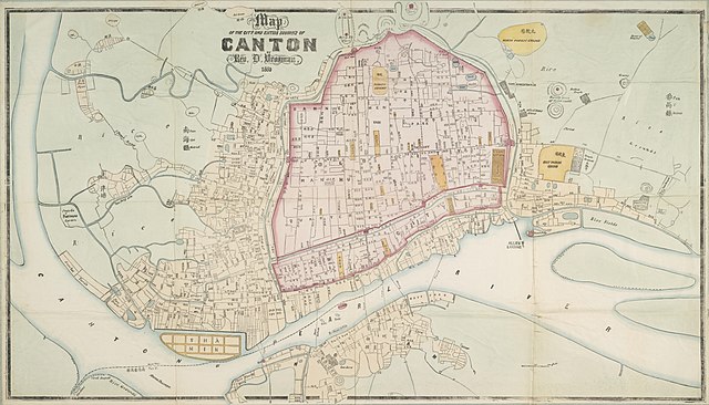
| Description |
English: "Map of the City and Entire Suburbs of Canton in 1860 by Rev. D. Vrooman", an updating of Vrooman's 1855 map of the city, incorporating the destruction of the Thirteen Factories, the erection of Shamian, and minor adjustments to his prospective map of the city following its opening to foreign visitors following the treaties of Tianjin and Beijing.
中文(简体):广州市1860年地图,藏于澳洲国家图书馆。
中文(繁體):廣州市1860年地圖,藏於澳洲國家圖書館。 |
||||||||||||||||
| दिनाङ्क | |||||||||||||||||
| स्रोत | http://www.nla.gov.au/apps/cdview/nla.map-lms636 | ||||||||||||||||
| रचियता |
|
||||||||||||||||
| Geotemporal data | |||||||||||||||||
| Bounding box |
|
||||||||||||||||
| Georeferencing | |||||||||||||||||
| दूसरे संस्करण | |||||||||||||||||

अधिकृत करब
|
This work is in the public domain in its country of origin and other countries and areas where the copyright term is the author's life plus 100 years or fewer. | |
| इस फ़ाइल को कॉपीराइट कानूनों के अंतर्गत सभी संबंधित अधिकारों समेत ज्ञात सीमाओं से मुक्त पहचाना गया है। | |
फाइल इतिहास
तखनका तिथि/ समए पर क्लिक करी जखनका फाइल देखबाक अछि
| तिथि/ समए | लघुचित्र | बीमसभ | प्रयोक्ता | समीक्षा | |
|---|---|---|---|---|---|
| अखनका | २०:१०, १७ जनवरी २०१८ | | ११,६८० × ६,६७२ (११.७२ MB) | User-duck | Cropped using CropTool with lossless mode. |
| १६:१९, २४ अगस्त २०११ |  | ११,९५२ × ७,५३६ (१३.९७ MB) | Gzdavidwong | {{Information |Description ={{en|1=Maps of Canton City in 1860.}} {{zh-hans|1=广州市1860年地图。}} {{zh-hant|1=廣州市1860年地圖。}} |Source ={{own}} |Author =Gzdavidwong |Date =1860 |Permissi |
फाइलक उपयोग
ई पृष्ठमे ई फाइलक लिङ्क अछि:
विश्वव्यापी फाइल उपयोग
ई फाइल कऽ उपयोग निम्न दोसर विकिसभमे अछि:
- en.wikipedia.org कऽ उपयोग पर
- fr.wikipedia.org कऽ उपयोग पर
- ha.wikipedia.org कऽ उपयोग पर
- ja.wikipedia.org कऽ उपयोग पर
- ru.wikipedia.org कऽ उपयोग पर
- www.wikidata.org कऽ उपयोग पर
- zh-yue.wikipedia.org कऽ उपयोग पर
- zh.wikipedia.org कऽ उपयोग पर