फाइल:Brunei location map Topographic.png

ऐ पूर्वदृश्यक आकार: ७३९ × ६०० चित्राणु. दोसर resolutions: २९६ × २४० चित्राणु | ५९१ × ४८० चित्राणु | ९४६ × ७६८ चित्राणु | १,२६२ × १,०२४ चित्राणु | २,३३१ × १,८९२ चित्राणु।
पूर्ण आनन्तर्य (२,३३१ × १,८९२ चित्राणु, फाइल आकार: ५.९२ MB, माइम प्रकार: image/png)
| ई फाइल विकिमिडिया कमन्ससँ अछि। कमन्सकs विवरण पृष्ठसँ जानकारी एतए नीचाँ देखाएल गेल अछि। कमन्स एक फ्रि लाइसेन्स मिडिया फाइल परियोजना छि। अपने मद्ददतकs सकए छि। |
सङ्क्षेप
| जानकारी |
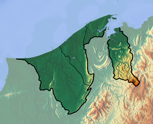
Deutsch: Positionskarte von Brunei
Quadratische Plattkarte. Geographische Begrenzung der Karte:
English: Location map of Brunei
Equirectangular projection. Geographic limits of the map:
|
| दिनाङ्क | |
| स्रोत |
अपन काम
|
| लेखक | Dr Brains |
अधिकृत करब
मैं, इस कार्य का/की कॉपीराइट धारक, इसे निम्न लाइसेंसों के अंतर्गत प्रकाशित करता/करती हूँ:

|
इस दस्तावेज़ को Free Software Foundation द्वारा प्रकाशित GNU मुक्त प्रलेख लाइसेंस के सिर्फ संस्करण 1.2 (बिना किसी अपरिवर्तनीय अनुभागों और अगले या पिछले आवरण के टेक्स्ट के) के अंतर्गत प्रतिलिपि बनाने, बाँटने और/या बदलने की अनुमति प्रदान की जाती है। इस लाइसेंस की एक प्रतिलिपि GNU मुक्त प्रलेख लाइसेंस नामक अनुभाग में शामिल है। | सिर्फ 1.2 |
|
|
Permission is granted to copy, distribute and/or modify this document under the terms of the GNU Free Documentation License, Version 1.3 or any later version published by the Free Software Foundation; with no Invariant Sections, no Front-Cover Texts, and no Back-Cover Texts. A copy of the license is included in the section entitled GNU Free Documentation License.
|
अहाँ अपन पसन्दक लाइसेन्स चुनि सकैत छी।
फाइल इतिहास
तखनका तिथि/ समए पर क्लिक करी जखनका फाइल देखबाक अछि
| तिथि/ समए | लघुचित्र | बीमसभ | प्रयोक्ता | समीक्षा | |
|---|---|---|---|---|---|
| अखनका | १७:०७, १० जुन २०१२ | | २,३३१ × १,८९२ (५.९२ MB) | Dr Brains |
फाइलक उपयोग
ई 2 पन्नासभमे ई फाइलक लिङ्क अछि:
विश्वव्यापी फाइल उपयोग
ई फाइल कऽ उपयोग निम्न दोसर विकिसभमे अछि:
- ar.wikipedia.org कऽ उपयोग पर
- ast.wikipedia.org कऽ उपयोग पर
- bcl.wikipedia.org कऽ उपयोग पर
- bn.wikipedia.org कऽ उपयोग पर
- bs.wikipedia.org कऽ उपयोग पर
- ceb.wikipedia.org कऽ उपयोग पर
- ce.wikipedia.org कऽ उपयोग पर
- cs.wikipedia.org कऽ उपयोग पर
- el.wikipedia.org कऽ उपयोग पर
- en.wikipedia.org कऽ उपयोग पर
- Brunei
- Geography of Brunei
- Bandar Seri Begawan
- Brunei Bay
- Jerudong Park
- Brunei Open
- Pagon Hill
- Aberdeen Brunei Senior Masters
- Tasek Merimbun
- Ulu Temburong National Park
- Module:Location map/data/Brunei/doc
- Batu Apoi Forest Reserve
- Seria oil field
- Benutan Dam
- Ulu Tutong Dam
- Ash-Shaliheen Mosque
- Pehin Khatib Abdullah Mosque
- Hassanal Bolkiah Mosque
- Hassanal Bolkiah Mosque, Mentiri
- Module:Location map/data/Brunei
- Kedayan River
- Kianggeh River
- Jerudong Park Amphitheater
- Saeh Hill
- Retak Hill
- Tudal Hill
- Lalak Lake
- Serasa Bay
- Teraja Waterfall
- fa.wikipedia.org कऽ उपयोग पर
- fr.wikipedia.org कऽ उपयोग पर
ई फाइलक विश्वव्यापी उपयोगक अधिक जानकारी देखी।