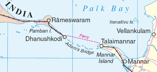
फाइल:Adams bridge map.png
Adams_bridge_map.png (५१९ × २३९ चित्राणु, फाइल आकार: २५ KB, माइम प्रकार: image/png)
फाइल इतिहास
तखनका तिथि/ समए पर क्लिक करी जखनका फाइल देखबाक अछि
| तिथि/ समए | लघुचित्र | बीमसभ | प्रयोक्ता | समीक्षा | |
|---|---|---|---|---|---|
| अखनका | ०७:४०, ४ अगस्त २००६ |  | ५१९ × २३९ (२५ KB) | Gugganij | Map of Adam's Bridge, India/Sri Lanka Extracted from http://www.un.org/Depts/Cartographic/map/profile/srilanka.pdf {{UN map}} |
फाइलक उपयोग
ई पृष्ठमे ई फाइलक लिङ्क अछि:
विश्वव्यापी फाइल उपयोग
ई फाइल कऽ उपयोग निम्न दोसर विकिसभमे अछि:
- ar.wikipedia.org कऽ उपयोग पर
- az.wikipedia.org कऽ उपयोग पर
- ba.wikipedia.org कऽ उपयोग पर
- be.wikipedia.org कऽ उपयोग पर
- bn.wikipedia.org कऽ उपयोग पर
- cs.wikipedia.org कऽ उपयोग पर
- de.wikipedia.org कऽ उपयोग पर
- el.wikipedia.org कऽ उपयोग पर
- en.wikipedia.org कऽ उपयोग पर
- eo.wikipedia.org कऽ उपयोग पर
- es.wikipedia.org कऽ उपयोग पर
- et.wikipedia.org कऽ उपयोग पर
- fi.wikipedia.org कऽ उपयोग पर
- fr.wikipedia.org कऽ उपयोग पर
- fy.wikipedia.org कऽ उपयोग पर
- gl.wikipedia.org कऽ उपयोग पर
- gu.wikipedia.org कऽ उपयोग पर
- he.wikipedia.org कऽ उपयोग पर
- hi.wikipedia.org कऽ उपयोग पर
- hu.wikipedia.org कऽ उपयोग पर
- id.wikipedia.org कऽ उपयोग पर
- it.wikipedia.org कऽ उपयोग पर
- ja.wikipedia.org कऽ उपयोग पर
- kn.wikipedia.org कऽ उपयोग पर
- ko.wikipedia.org कऽ उपयोग पर
- la.wikipedia.org कऽ उपयोग पर
- lt.wikipedia.org कऽ उपयोग पर
- mk.wikipedia.org कऽ उपयोग पर
- ml.wikipedia.org कऽ उपयोग पर
ई फाइलक विश्वव्यापी उपयोगक अधिक जानकारी देखी।

