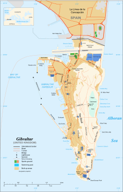
गिब्राल्टार
गिब्राल्टार (अङ्ग्रेजी: Gibraltar जिब्रल्तार) इबेरियन प्रायद्विपक छेउ तथा मेडिटेरियनक शुरुक भागमे अवस्थित बेलायती स्वशासित भूभाग छी । एकर क्षेत्रफल ६८ वर्ग किलोमिटर अछि । एकर उत्तरी सिमाना स्पेनक एन्डालुसिया संग जोडिएल अछि । गिब्राल्टार क्षेत्रक प्रमुख सिमाचिन्ह गिब्राल्टारक चट्टान छी ।
गिब्राल्टार (Gibraltar) | |
|---|---|
आदर्श वाक्य: "Nulli Expugnabilis Hosti" (Latin) "Conquerable by No Enemy" | |
![गिब्राल्टार के स्थान (dark green) – in Europe (green आर dark grey) – युरोपेली सङ्घ (green) – [नक्सा]](http://upload.wikimedia.org/wikipedia/commons/thumb/7/72/Location_Gibraltar_EU.png/250px-Location_Gibraltar_EU.png) गिब्राल्टार के स्थान (dark green) – in Europe (green आर dark grey) | |
 Map of Gibraltar | |
| राजधानी | गिब्राल्टार |
| सबैभन्दा ठुलो जिला (by population) | Westside |
| आधिकारिक भाषासभ | अङ्ग्रेजी |
| भाषासभ |
|
| जातिगत समूहसभ | |
| मूलवासी(सभ) | गिब्ररल्टारी |
| सरकार | British overseas territoryb |
• Monarch | Elizabeth II |
• Governor | Sir Adrian Johns |
| Fabian Picardo | |
| Event Date | |
• Captured | 4 August 1704[२] |
• Ceded | 11 April 1713[३] |
| 10 September | |
| 29 January | |
| क्षेत्रफल | |
• कुल | ६.८ किमी२ (२.६ वर्ग माइल) (241st) |
• पानी (%) | 0 |
| जनसङ्ख्या | |
• 2009 अनुमानित | 29,431 (211th) |
• घनत्व | ४,३२८ /किमी2 (११,२०९.५ /वर्ग माइल) (5th) |
| कुल ग्राहस्थ उत्पादन (क्रय शक्ति समता) | 2011 लगत |
• कुल | £1 billion |
• प्रति व्यक्ति | £27,468 (n/a) |
| मानव विकास सूचकाङ्क (2011) | 0.863 त्रुटि: अमान्य एचडिआई मान · 28th |
| मुद्रा | Gibraltar pound £d (GIP) |
| समय क्षेत्र | अन्तर्राष्ट्रिय प्रमाणिक समय+1 (CET) |
• ग्रीष्मकालीन (दिवाप्रकाश समय बचत) | अन्तर्राष्ट्रिय प्रमाणिक समय+2 (CEST) |
| तिथि आकृति | dd/mm/yyyy |
| सडक प्रयोग | righte |
| टेलिफोन कोड | 350g |
| इन्टरनेट डोमेन | .gif |
| |
इतिहास
सम्पादन करीमुख्य लेख: गिब्राल्टारक इतिहास
मौसम
सम्पादन करी| Gibraltar-कऽ लेल मौसम जानकारी | |||||||||||||
|---|---|---|---|---|---|---|---|---|---|---|---|---|---|
| महिना | जन | फर | मार्च | अप्रैल | मई | जुन | जुलाई | अगस्त | सित | अक्टु | नव | दिस | वर्ष |
| अधिकतम °से (°फे) औषत | १६ (६१) |
१७ (६३) |
१८ (६४) |
२० (६८) |
२३ (७३) |
२५ (७७) |
२८ (८२) |
२९ (८४) |
२६ (७९) |
२३ (७३) |
१९ (६६) |
१७ (६३) |
२१٫८ (७१٫१) |
| दैनिक औषत °से (°फे) | १३ (५५) |
१४ (५७) |
१५ (५९) |
१७ (६३) |
१९ (६६) |
२२ (७२) |
२४ (७५) |
२५ (७७) |
२३ (७३) |
२० (६८) |
१७ (६३) |
१४ (५७) |
१८٫६ (६५٫४) |
| न्यूनतम °से (°फे) औषत | १० (५०) |
११ (५२) |
१२ (५४) |
१३ (५५) |
१५ (५९) |
१८ (६४) |
२० (६८) |
२१ (७०) |
१९ (६६) |
१७ (६३) |
१४ (५७) |
११ (५२) |
१५٫१ (५९٫२) |
| औषत हिमपात/वर्षा मीमी (इञ्च) | १५२ (५٫९८) |
९८ (३٫८६) |
१०६ (४٫१७) |
५९ (२٫३२) |
२५ (०٫९८) |
४ (०٫१६) |
१ (०٫०४) |
३ (०٫१२) |
२३ (०٫९१) |
५५ (२٫१७) |
११४ (४٫४९) |
१२७ (५) |
७६७ (३०٫२) |
| वर्षात दैनिक औषत | १० | ७ | १० | ६ | ४ | १ | ० | १ | २ | ५ | ७ | १० | ६३ |
| मासिक औषत सौर्य प्रकाश अवधि | १८६٫० | १९६٫० | २१७٫० | २४०٫० | ३१०٫० | ३३०٫० | ३४१٫० | ३४१٫० | २७०٫० | २१७٫० | १८०٫० | १८६٫० | ३,०१४ |
| स्रोत: BBC Weather[४] | |||||||||||||
सन्दर्भ सामग्रीसभ
सम्पादन करी- ↑ "Gibraltar: National anthem"। CIA World Factbook। Central Intelligence Agency। मूलसँ 12 April 2018 कऽ सङ्ग्रहित। अन्तिम पहुँच 25 September 2011।
National anthem: name: "Gibraltar Anthem" . . . note:adopted 1994; serves as a local anthem; as a territory of the United Kingdom, "God Save the Queen" remains official (see United Kingdom)
{{cite web}}: Unknown parameter|dead-url=ignored (|url-status=suggested) (help) - ↑ Gibraltar was captured on 24 July 1704 Old Style or 4 August 1704 New Style.
- ↑ The treaty was signed on 31 March 1713 Old Style or 11 April 1713 New Style (Peace and Friendship Treaty of Utrecht between France and Great Britain).
- ↑ "BBC Weather | Gibraltar"। BBC News। 29 January 2010। अन्तिम पहुँच 6 November 2011।
बाह्य जडीसभ
सम्पादन करीGibraltarक सम्बन्धमे विकिपिडियाक भातृ योजनासभमे ताकी:
| परिभाषा विकिस्नरीसँ | |
| पाठ्यपुस्तक विकिपुस्तकसँ | |
| उद्घरण विकिउद्रघरणसँ | |
| स्रोत पदसभ विकिस्रोतसँ | |
| चित्र आ मिडीया कमन्ससँ | |
| समाचार विकिसमाचारसँ | |
| सिखैवाला स्रोतसभ विकिभर्सिटीसँ |
- Interactive Map of Gibraltar
- Gibraltar.com – Complete information portal for Gibraltar
- Government of Gibraltar
निर्देशाङ्क: ३६°०८′३५″N ५°२१′११″W / ३६.१४३°N ५.३५३°W
| विकिमिडिया कमन्समे Gibraltarसँ सम्बन्धित मिडिया अछि। |

